
Make a donation
Walla Walla topographic map
Click on the map to display elevation.
Make a donation
Walla Walla
Walla Walla County features a varied topography characterized by rolling hills, valleys, and river systems. The elevation in the area averages around 940 feet (approximately 287 meters) above sea level, with some areas rising to nearly 1,200 feet. The landscape is shaped by the Walla Walla River, which carves through the valley, providing a lush riparian environment that contrasts with the arid foothills surrounding it. The region’s terrain consists of fertile plains ideal for agriculture, especially viticulture, while the foothills transition into higher elevations that offer panoramic views of the valley below. This combination of hills and valleys not only supports a diverse ecosystem but also creates an appealing environment for outdoor activities like hiking and wine tasting, attracting visitors to its scenic vistas.
Make a donation
About this map
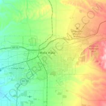
Name: Walla Walla topographic map, elevation, terrain.
Average elevation: 297 m
Minimum elevation: 209 m
Maximum elevation: 417 m
Make a donation
Other topographic maps
Click on a map to view its topography, its elevation and its terrain.
Whitman Mission National Historic Site
United States > Washington > Walla Walla County
Average elevation: 196 m
Make a donation