
Thank you for supporting this site ❤️
Make a donation
Make a donation
Mangunsari topographic map
Click on the map to display elevation.
Thank you for supporting this site ❤️
Make a donation
Make a donation
About this map
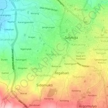
Name: Mangunsari topographic map, elevation, terrain.
Location: Mangunsari, Salatiga, Central Java, Java, 50721, Indonesia (-7.35648 110.47307 -7.31648 110.51307)
Average elevation: 592 m
Minimum elevation: 493 m
Maximum elevation: 712 m
Thank you for supporting this site ❤️
Make a donation
Make a donation
Other topographic maps
Click on a map to view its topography, its elevation and its terrain.
Gantangan Burung Bung Karno Dukuh Salatiga
Indonesia > Central Java > Salatiga > Dukuh > Glogolan
Average elevation: 599 m