
Kabale topographic map
Interactive map
Click on the map to display elevation.
About this map
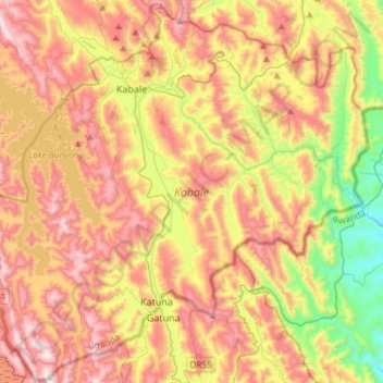
Name: Kabale topographic map, elevation, terrain.
Location: Kabale, Western Region, Ouganda (-1.48232 29.72836 -0.98557 30.30121)
Average elevation: 1,850 m
Minimum elevation: 1,322 m
Maximum elevation: 2,599 m
Other topographic maps
Click on a map to view its topography, its elevation and its terrain.
Lake Bunyonyi
Lake Bunyonyi, Bufuka, Kabale, Western Region, Ouganda
Average elevation: 2,047 m