
City of Durham topographic map
Interactive map
Click on the map to display elevation.
About this map
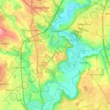
Name: City of Durham topographic map, elevation, terrain.
Average elevation: 76 m
Minimum elevation: 26 m
Maximum elevation: 139 m
Other topographic maps
Click on a map to view its topography, its elevation and its terrain.
Observatory Hill
United Kingdom > England > County Durham > Durham
Observatory Hill, Durham, County Durham, North East, England, DH1 4SZ, United Kingdom
Average elevation: 73 m
Pelton Fell
United Kingdom > England > County Durham > Durham
Pelton Fell, Durham, County Durham, North East, England, DH2 2QA, United Kingdom
Average elevation: 76 m
Flass Vale Local Nature Reserve
United Kingdom > England > County Durham > Durham
Flass Vale Local Nature Reserve, Durham North End Allotments, City of Durham, Durham, County Durham, North East, England, United Kingdom
Average elevation: 81 m
Houghall
United Kingdom > England > County Durham > Durham
Houghall, City of Durham, Durham, County Durham, North East, England, DH1 3SF, United Kingdom
Average elevation: 69 m