
Thank you for supporting this site ❤️
Make a donation
Make a donation
Billups topographic map
Click on the map to display elevation.
Thank you for supporting this site ❤️
Make a donation
Make a donation
About this map
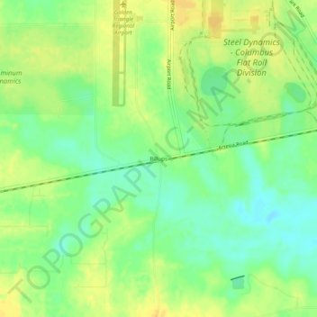
Name: Billups topographic map, elevation, terrain.
Location: Billups, Lowndes County, Mississippi, United States (33.41068 -88.60505 33.45068 -88.56505)
Average elevation: 72 m
Minimum elevation: 58 m
Maximum elevation: 84 m
Thank you for supporting this site ❤️
Make a donation
Make a donation
Other topographic maps
Click on a map to view its topography, its elevation and its terrain.