
Make a donation
Parque Bicentenario topographic map
Click on the map to display elevation.
Make a donation
About this map
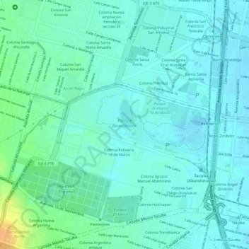
Name: Parque Bicentenario topographic map, elevation, terrain.
Average elevation: 2,252 m
Minimum elevation: 2,243 m
Maximum elevation: 2,277 m
Make a donation
Other topographic maps
Click on a map to view its topography, its elevation and its terrain.
Mexico City
Mexico > Mexico City > Mexico City
Mexico City is located in the Valley of Mexico, sometimes called the Basin of Mexico. This valley is located in the Trans-Mexican Volcanic Belt in the high plateaus of south-central Mexico. It has a minimum altitude of 2,200 meters (7,200 feet) above sea level and is surrounded by mountains and volcanoes that…
Average elevation: 2,321 m
Álvaro Obregón
Mexico > Mexico City > Mexico City
Álvaro Obregón (Spanish pronunciation: [ˈalβaɾo oβɾeˈɣon]) is a borough (demarcación territorial) in Mexico City. It contains a large portion of the south-west part of Mexico City. It had a 2020 census population of 759,137 inhabitants and lies at an elevation of 2,319 m. above sea level.
Average elevation: 2,457 m
Make a donation
Make a donation
Make a donation