
Clyde Muirshiel Regional Park topographic map
Interactive map
Click on the map to display elevation.
About this map
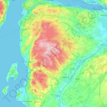
Name: Clyde Muirshiel Regional Park topographic map, elevation, terrain.
Location: Clyde Muirshiel Regional Park, Inverclyde, Écosse, Royaume-Uni (55.68030 -4.88782 55.94786 -4.56339)
Average elevation: 126 m
Minimum elevation: -13 m
Maximum elevation: 514 m
Other topographic maps
Click on a map to view its topography, its elevation and its terrain.
Greenock
Royaume-Uni > Écosse > Inverclyde
Greenock, Inverclyde, Écosse, PA15 1LT, Royaume-Uni
Average elevation: 80 m