
Thank you for supporting this site ❤️
Make a donation
Make a donation
Les Cayes topographic map
Click on the map to display elevation.
Thank you for supporting this site ❤️
Make a donation
Make a donation
About this map
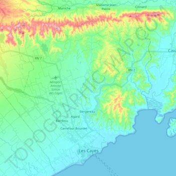
Name: Les Cayes topographic map, elevation, terrain.
Location: Les Cayes, Arrondissement des Cayes, Sud Department, Haiti (18.16939 -73.87574 18.35061 -73.68113)
Average elevation: 70 m
Minimum elevation: -1 m
Maximum elevation: 356 m
Thank you for supporting this site ❤️
Make a donation
Make a donation
Other topographic maps
Click on a map to view its topography, its elevation and its terrain.
Thank you for supporting this site ❤️
Make a donation
Make a donation
Île-à-Vache
Haiti > Sud Department > Commune Île-à-Vache
The island is about 8 miles (13 km) long and 2 miles (3.2 km) wide, with an area of 20 square miles (52 km2). The western end of the island has rolling hills with elevations as high as 490 feet (150 m) with several small swamps in the valleys; the eastern side of the island is swampy, and contains a lagoon…
Average elevation: 2 m
Thank you for supporting this site ❤️
Make a donation
Make a donation