
Make a donation
Beckwourth topographic map
Click on the map to display elevation.
Make a donation
About this map
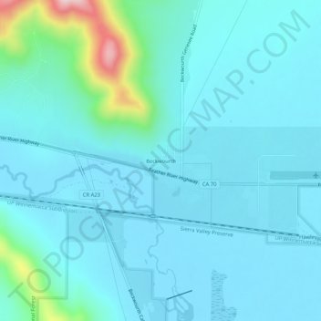
Name: Beckwourth topographic map, elevation, terrain.
Average elevation: 1,526 m
Minimum elevation: 1,482 m
Maximum elevation: 1,833 m
Make a donation
Other topographic maps
Click on a map to view its topography, its elevation and its terrain.
Lake Almanor Country Club
United States > California > Plumas County > Peninsula Village
Average elevation: 1,388 m
Quincy
United States > California > Plumas County > Quincy
Quincy has a Mediterranean climate (Köppen Csb) though its inland location and altitude makes it more continental and wetter than usual for this type, with very heavy snowfalls sometimes occurring in winter – the record being 133 inches (337.8 cm) in the very wet January 1916. Although summer days are hot…
Average elevation: 1,274 m
Make a donation
Little Grass Valley
United States > California > Plumas County > La Porte
About 2.5 miles (4.0 km) north of Little Grass Valley Lake lies a small, natural lily pond called Fowler Lake. Its coordinates are 39°46′27″N 121°00′19″W / 39.77417°N 121.00528°W / 39.77417; -121.00528 (Fowler Lake), and its altitude is 5,446 feet (1,660 m).
Average elevation: 1,644 m
Make a donation
Make a donation
Lake Almanor Peninsula
United States > California > Plumas County > Peninsula Village
Average elevation: 1,429 m
Make a donation
Quincy
United States > California > Plumas County
Quincy has a Mediterranean climate (Köppen Csb) though its inland location and altitude makes it more continental and wetter than usual for this type, with very heavy snowfalls sometimes occurring in winter – the record being 133 inches (337.8 cm) in the very wet January 1916. Although summer days are hot…
Average elevation: 1,274 m
Make a donation