
Thank you for supporting this site ❤️
Make a donation
Make a donation
Sandhikharka topographic map
Click on the map to display elevation.
Thank you for supporting this site ❤️
Make a donation
Make a donation
About this map
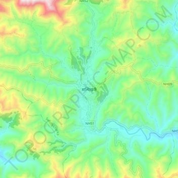
Name: Sandhikharka topographic map, elevation, terrain.
Location: Sandhikharka, Arghakhanchi, Lumbini Province, 32700, Nepal (27.93570 83.08711 28.01570 83.16711)
Average elevation: 1,119 m
Minimum elevation: 845 m
Maximum elevation: 1,750 m
Thank you for supporting this site ❤️
Make a donation
Make a donation
Other topographic maps
Click on a map to view its topography, its elevation and its terrain.