
Amherst Glacier topographic map
Interactive map
Click on the map to display elevation.
About this map
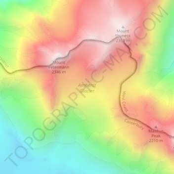
Name: Amherst Glacier topographic map, elevation, terrain.
Average elevation: 1,819 m
Minimum elevation: 1,252 m
Maximum elevation: 2,338 m
Other topographic maps
Click on a map to view its topography, its elevation and its terrain.
Mount Russel
Nouvelle-Zélande > West Coast > Westland District
Mount Russel, Westland District, West Coast, Nouvelle-Zélande
Average elevation: 1,384 m
Franz Josef
Nouvelle-Zélande > West Coast > Westland District > Franz Josef / Waiau
Franz Josef, Fox Glacier Highway, Franz Josef / Waiau, Westland District, West Coast, 7856, Nouvelle-Zélande
Average elevation: 159 m