
Thank you for supporting this site ❤️
Make a donation
Make a donation
Bayport topographic map
Click on the map to display elevation.
Thank you for supporting this site ❤️
Make a donation
Make a donation
About this map
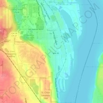
Name: Bayport topographic map, elevation, terrain.
Location: Bayport, Washington County, Minnesota, 55003, United States (44.99946 -92.79739 45.03020 -92.76199)
Average elevation: 230 m
Minimum elevation: 203 m
Maximum elevation: 280 m
Thank you for supporting this site ❤️
Make a donation
Make a donation
Other topographic maps
Click on a map to view its topography, its elevation and its terrain.
St. Croix River Boom Site Landing
United States > Minnesota > Washington County > Stillwater Township
Average elevation: 253 m
Grey Cloud Island
United States > Minnesota > Washington County > Grey Cloud Island Township
Average elevation: 225 m
Twin Pine Mobile Home Park
United States > Minnesota > Washington County > Hugo
Average elevation: 282 m