
Thank you for supporting this site ❤️
Make a donation
Make a donation
Domaine du Rond Chene topographic map
Click on the map to display elevation.
Thank you for supporting this site ❤️
Make a donation
Make a donation
About this map
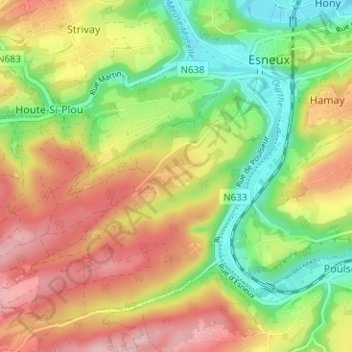
Name: Domaine du Rond Chene topographic map, elevation, terrain.
Location: Domaine du Rond Chene, Esneux, Liège, Wallonie, 4130, Belgique (50.50031 5.53205 50.54031 5.57205)
Average elevation: 174 m
Minimum elevation: 75 m
Maximum elevation: 282 m
Thank you for supporting this site ❤️
Make a donation
Make a donation
Other topographic maps
Click on a map to view its topography, its elevation and its terrain.
Thank you for supporting this site ❤️
Make a donation
Make a donation