
Thank you for supporting this site ❤️
Make a donation
Make a donation
Laufdorf topographic map
Click on the map to display elevation.
Thank you for supporting this site ❤️
Make a donation
Make a donation
About this map
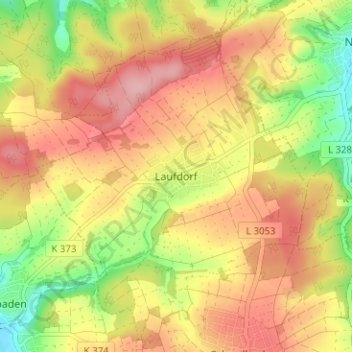
Name: Laufdorf topographic map, elevation, terrain.
Location: Laufdorf, Шёффенгрунд, Lahn-Dill-Kreis, Гессен, 35641, Германия (50.49608 8.43838 50.53608 8.47838)
Average elevation: 248 m
Minimum elevation: 170 m
Maximum elevation: 308 m
Thank you for supporting this site ❤️
Make a donation
Make a donation
Other topographic maps
Click on a map to view its topography, its elevation and its terrain.
Вецлар
Германия > Гессен > Lahn-Dill-Kreis
Вецлар расположен в районе Лан-Дилль и является его административным центром. Город стоит на берегу реки Лан, притока Рейна, близ места впадения в Лан реки Дилль.…
Average elevation: 232 m