
Allendorf topographic map
Interactive map
Click on the map to display elevation.
About this map
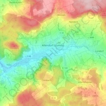
Name: Allendorf topographic map, elevation, terrain.
Location: Allendorf, Landkreis Gießen, Hessen, 35469, Deutschland (50.64604 8.77963 50.70268 8.84583)
Average elevation: 280 m
Minimum elevation: 186 m
Maximum elevation: 393 m
Other topographic maps
Click on a map to view its topography, its elevation and its terrain.
Nordeck
Deutschland > Hessen > Landkreis Gießen > Allendorf
Nordeck, Nordeck-Winnen, Allendorf, Landkreis Gießen, Hessen, Deutschland
Average elevation: 314 m
Allendorf
Deutschland > Hessen > Landkreis Gießen > Allendorf
Allendorf, Landkreis Gießen, Hessen, 35469, Deutschland
Average elevation: 280 m
Allendorf (Lumda)
Deutschland > Hessen > Landkreis Gießen > Allendorf > Allendorf (Lumda)
Allendorf (Lumda), Allendorf, Landkreis Gießen, Hessen, 35469, Deutschland
Average elevation: 284 m
Nordeck
Deutschland > Hessen > Landkreis Gießen > Allendorf > Nordeck
Nordeck, Allendorf, Landkreis Gießen, Hessen, 35469, Deutschland
Average elevation: 298 m