
Kegalle District topographic map
Interactive map
Click on the map to display elevation.
About this map
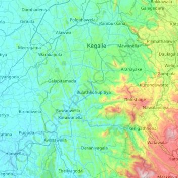
Name: Kegalle District topographic map, elevation, terrain.
Location: Kegalle District, Sabaragamuwa Province, Sri Lanka (6.83001 80.14537 7.39661 80.54813)
Average elevation: 309 m
Minimum elevation: 5 m
Maximum elevation: 1,938 m
Other topographic maps
Click on a map to view its topography, its elevation and its terrain.