
Malargüe topographic map
Interactive map
Click on the map to display elevation.
About this map
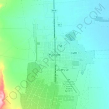
Name: Malargüe topographic map, elevation, terrain.
Average elevation: 1,424 m
Minimum elevation: 1,381 m
Maximum elevation: 1,609 m
Other topographic maps
Click on a map to view its topography, its elevation and its terrain.
Plaza Guemes
Argentina > Mendoza > Malargüe
Plaza Guemes, Martín M. de Güemes, Malargüe, Distrito Ciudad de Malargüe, Departamento Malargüe, Mendoza, Argentina
Average elevation: 1,432 m