
Thank you for supporting this site ❤️
Make a donation
Make a donation
Bijuri topographic map
Click on the map to display elevation.
Thank you for supporting this site ❤️
Make a donation
Make a donation
About this map
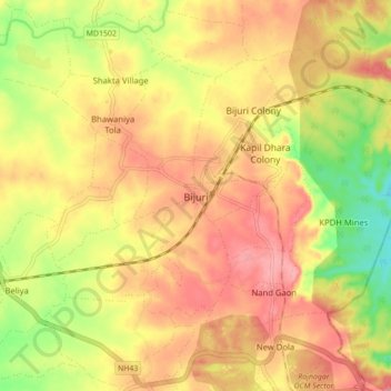
Name: Bijuri topographic map, elevation, terrain.
Location: Bijuri, Kotma Tehsil, Anuppur, Madhya Pradesh, 484440, India (23.21074 82.07603 23.29074 82.15603)
Average elevation: 557 m
Minimum elevation: 499 m
Maximum elevation: 595 m
Thank you for supporting this site ❤️
Make a donation
Make a donation
Other topographic maps
Click on a map to view its topography, its elevation and its terrain.