
Thank you for supporting this site ❤️
Make a donation
Make a donation
Freda topographic map
Click on the map to display elevation.
Thank you for supporting this site ❤️
Make a donation
Make a donation
About this map
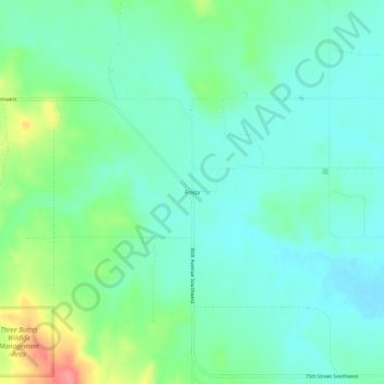
Name: Freda topographic map, elevation, terrain.
Location: Freda, Grant County, North Dakota, United States (46.32722 -101.19375 46.36722 -101.15375)
Average elevation: 584 m
Minimum elevation: 562 m
Maximum elevation: 646 m
Thank you for supporting this site ❤️
Make a donation
Make a donation
Other topographic maps
Click on a map to view its topography, its elevation and its terrain.