
Thank you for supporting this site ❤️
Make a donation
Make a donation
Judaita topographic map
Click on the map to display elevation.
Thank you for supporting this site ❤️
Make a donation
Make a donation
About this map
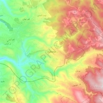
Name: Judaita topographic map, elevation, terrain.
Location: Judaita, Koorah Sub-District, Koorah District, Irbid, Jordan (32.36874 35.66696 32.44874 35.74696)
Average elevation: 585 m
Minimum elevation: 216 m
Maximum elevation: 976 m
Thank you for supporting this site ❤️
Make a donation
Make a donation
Other topographic maps
Click on a map to view its topography, its elevation and its terrain.