
Valdivia topographic map
Interactive map
Click on the map to display elevation.
About this map
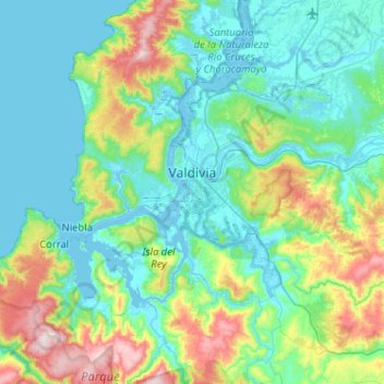
Name: Valdivia topographic map, elevation, terrain.
Location: Valdivia, Provincia de Valdivia, Región de Los Ríos, Chile (-40.03202 -73.41394 -39.63714 -72.92085)
Average elevation: 143 m
Minimum elevation: -3 m
Maximum elevation: 705 m
Other topographic maps
Click on a map to view its topography, its elevation and its terrain.
Isla Teja
Chile > Región de Los Ríos > Valdivia
Isla Teja, Valdivia, Provincia de Valdivia, Región de Los Ríos, Chile
Average elevation: 19 m