
Skye Island topographic map
Interactive map
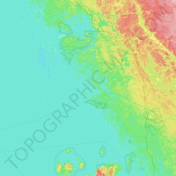
Click on the map to display elevation.
About this map
Name: Skye Island topographic map, elevation, terrain.
Average elevation: 199 m
Minimum elevation: 171 m
Maximum elevation: 335 m
Other topographic maps
Click on a map to view its topography, its elevation and its terrain.
Doll Island
Canada > Ontario > The Archipelago
Doll Island, The Archipelago, Parry Sound District, Ontario, Canada
Average elevation: 200 m
Annette Island
Canada > Ontario > The Archipelago
Annette Island, The Archipelago, Parry Sound District, Ontario, Canada
Average elevation: 198 m
St. Helens Island
Canada > Ontario > The Archipelago
St. Helens Island, The Archipelago, Parry Sound District, Ontario, Canada
Average elevation: 189 m