
Thank you for supporting this site ❤️
Make a donation
Make a donation
Wernigerode topographic map
Click on the map to display elevation.
Thank you for supporting this site ❤️
Make a donation
Make a donation
About this map
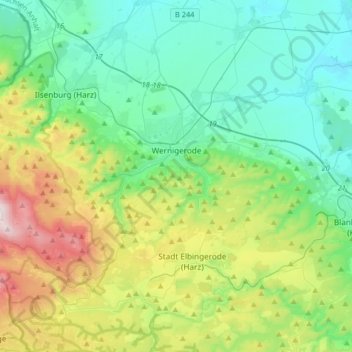
Name: Wernigerode topographic map, elevation, terrain.
Location: Wernigerode, Landkreis Harz, Saxony-Anhalt, Germany (51.75220 10.57385 51.88704 10.90049)
Average elevation: 381 m
Minimum elevation: 139 m
Maximum elevation: 1,062 m
Thank you for supporting this site ❤️
Make a donation
Make a donation
Other topographic maps
Click on a map to view its topography, its elevation and its terrain.
Brocken
Germany > Saxony-Anhalt > Landkreis Harz > Wernigerode
The Brocken, also sometimes referred to as the Blocksberg, is the highest peak in the Harz mountain range and also the highest peak in Northern Germany; it is near Schierke in the German state of Saxony-Anhalt between the rivers Weser and Elbe. Although its elevation of 1,141 metres (3,743 ft) is below alpine…
Average elevation: 963 m