
Make a donation
Mountain Park topographic map
Click on the map to display elevation.
Make a donation
About this map
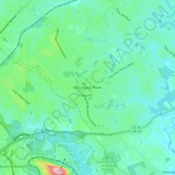
Name: Mountain Park topographic map, elevation, terrain.
Average elevation: 292 m
Minimum elevation: 239 m
Maximum elevation: 513 m
Make a donation
Other topographic maps
Click on a map to view its topography, its elevation and its terrain.
Buford
United States > Georgia > Gwinnett County
Buford is located in both northern Gwinnett County in northern Georgia, with a small portion extending north into Hall County. The city is a suburb within the Atlanta metropolitan area. According to the United States Census Bureau, as of 2010 the city has a total land area of 17.09 square miles (44.26 km2), of…
Average elevation: 340 m
Make a donation
Snellville
United States > Georgia > Gwinnett County
Compared to most large cities around the world at approximately the same latitude (33°39'), such as Beirut, Casablanca, Dallas, Los Angeles, and Phoenix, Snellville has lower average winter temperatures. The primary reason for this is that the North American continent extends into high latitudes that allows…
Average elevation: 300 m
Buford
United States > Georgia > Gwinnett County
Buford is located in both northern Gwinnett County in northern Georgia, with a small portion extending north into Hall County. The city is a suburb within the Atlanta metropolitan area. According to the United States Census Bureau, as of 2010 the city has a total land area of 17.09 square miles (44.26 km2), of…
Average elevation: 340 m
Make a donation
Yellow River Post Office Site
United States > Georgia > Gwinnett County > Lilburn
Average elevation: 275 m
Make a donation
Sugar Hill
United States > Georgia > Gwinnett County
According to the United States Census Bureau, as of 2010 the city of Sugar Hill had a total land area of 10.6 square miles (27.5 km2), of which 0.04 square miles (0.1 km2), or 0.33%, was water. The U.S. Geological Survey lists the city's elevation as 1,149 feet (350 m).
Average elevation: 332 m
Make a donation
Make a donation
Sugar Hill
United States > Georgia > Gwinnett County
According to the United States Census Bureau, as of 2010 the city of Sugar Hill had a total land area of 10.6 square miles (27.5 km2), of which 0.04 square miles (0.1 km2), or 0.33%, was water. The U.S. Geological Survey lists the city's elevation as 1,149 feet (350 m).
Average elevation: 332 m
Make a donation
Snellville
United States > Georgia > Gwinnett County
Compared to most large cities around the world at approximately the same latitude (33°39'), such as Beirut, Casablanca, Dallas, Los Angeles, and Phoenix, Snellville has lower average winter temperatures. The primary reason for this is that the North American continent extends into high latitudes that allows…
Average elevation: 300 m
Make a donation
Sugar Hill
United States > Georgia > Gwinnett County
According to the United States Census Bureau, as of 2010 the city of Sugar Hill had a total land area of 10.6 square miles (27.5 km2), of which 0.04 square miles (0.1 km2), or 0.33%, was water. The U.S. Geological Survey lists the city's elevation as 1,149 feet (350 m).
Average elevation: 332 m