
Thank you for supporting this site ❤️
Make a donation
Make a donation
Rakhiv Raion topographic map
Click on the map to display elevation.
Thank you for supporting this site ❤️
Make a donation
Make a donation
About this map
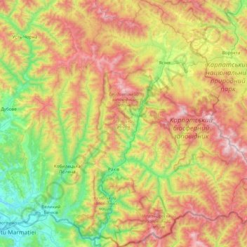
Name: Rakhiv Raion topographic map, elevation, terrain.
Location: Rakhiv Raion, Zakarpattia Oblast, Ukraine (47.89689 23.89215 48.39841 24.62747)
Average elevation: 953 m
Minimum elevation: 258 m
Maximum elevation: 2,043 m
Thank you for supporting this site ❤️
Make a donation
Make a donation
Other topographic maps
Click on a map to view its topography, its elevation and its terrain.
Thank you for supporting this site ❤️
Make a donation
Make a donation
Thank you for supporting this site ❤️
Make a donation
Make a donation