
Thank you for supporting this site ❤️
Make a donation
Make a donation
Thorr topographic map
Click on the map to display elevation.
Thank you for supporting this site ❤️
Make a donation
Make a donation
Thorr
Thorr liegt etwa 1 km südlich des Bergheimer Stadtzentrums und 20 km westlich von Köln auf einer Höhe von 67 m ü. NHN an der Mündung des Wiebachs in die Große Erft. Nach Norden wird der Ort durch die Bundesautobahn 61 (Anschlussstelle Bergheim Süd) und die Erft von Bergheim getrennt. Nordwestlich des Ortes, an der Ausfahrt Bergheim, kreuzen sich die Bundesstraße 55 und die Bundesstraße 477.
Thank you for supporting this site ❤️
Make a donation
Make a donation
About this map
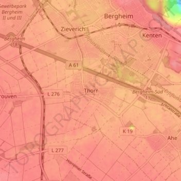
Name: Thorr topographic map, elevation, terrain.
Average elevation: 69 m
Minimum elevation: -11 m
Maximum elevation: 85 m
Thank you for supporting this site ❤️
Make a donation
Make a donation
Other topographic maps
Click on a map to view its topography, its elevation and its terrain.