
Aldreth topographic map
Click on the map to display elevation.
About this map
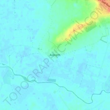
Name: Aldreth topographic map, elevation, terrain.
Average elevation: 5 m
Minimum elevation: -1 m
Maximum elevation: 39 m
Other topographic maps
Click on a map to view its topography, its elevation and its terrain.
River Great Ouse or Ely Ouse
United Kingdom > England > Cambridgeshire > East Cambridgeshire > Soham > Stuntney
Average elevation: 4 m
Westley Waterless
United Kingdom > England > Cambridgeshire > East Cambridgeshire
Average elevation: 92 m
Stretham
United Kingdom > England > Cambridgeshire > East Cambridgeshire > Stretham
Average elevation: 4 m
Little Thetford
United Kingdom > England > Cambridgeshire > East Cambridgeshire
Average elevation: 5 m
Chippenham
United Kingdom > England > Cambridgeshire > East Cambridgeshire > Chippenham
Average elevation: 22 m
Swaffham Prior
United Kingdom > England > Cambridgeshire > East Cambridgeshire
Average elevation: 11 m
Swaffham Bulbeck
United Kingdom > England > Cambridgeshire > East Cambridgeshire
Average elevation: 14 m