
Make a donation
Barinas State topographic map
Click on the map to display elevation.
Make a donation
Barinas State
[[Archivo:Osoid_culture.svg|link=https://es.wikipedia.org/wiki/Archivo:Osoid_culture.svg%7Cleft%7Cthumb%7CExtent of the Orinoco culture from 1000 BC to 1550 AD. In 500, the Orinoco people built the first mounds and causeways of Llanos]] The first known inhabitants of Barinas were the peoples of the Osoid culture. The Osoid people inhabited the middle elevations of the Llanos and were fishermen, hunters, and maize farmers. Their first archaeological evidence is from the Caño del Oso phase of 1000 BC, probably originating from a trade network linked to the Arawaks on the Negro, Orinoco, and Apure rivers. Between 180 BC and 550 AD, the Osoid people expanded north and interacted with the Tocuyanoid people of Lara. In 500 AD, interaction with groups from the Orinoco gave rise to the La Betania phase, during which agricultural production accelerated with the introduction of cassava and pollock corn. During this time, the Osoid people built the first mounds and causeways in the Llanos. By 600 AD, chiefdom societies were probably formed in towns such as Gaván. Between 1200 and 1550, the Ossoids expanded throughout Portuguesa as ethnic diversity in the region increased, with the arrival of tierroid peoples from Lara, dabajuroids from Falcón, and arauquinoids from Apure.
Make a donation
About this map
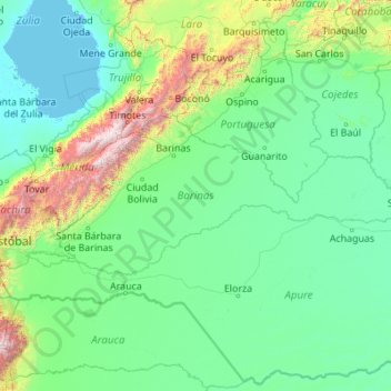
Name: Barinas State topographic map, elevation, terrain.
Location: Barinas State, Venezuela (7.28714 -71.87836 9.06075 -67.50243)
Average elevation: 365 m
Minimum elevation: -4 m
Maximum elevation: 4,773 m
Make a donation
Other topographic maps
Click on a map to view its topography, its elevation and its terrain.
Make a donation
Cueva del Guácharo
Venezuela > Monagas State > Municipio Caripe > La Laguna > Corral Viejo
Average elevation: 1,319 m
Make a donation
Valencia
Venezuela > Carabobo State > Municipio Valencia
The elevation of the city is 520 metres (1,710 feet).
Average elevation: 534 m
Make a donation
Guiana Highlands
Venezuela > Bolivar State > Municipio Angostura
The Guiana Shield (French: Plateau des Guyanes, Bouclier guyanais; Dutch: Hoogland van Guyana, Guianaschild; Portuguese: Planalto das Guianas, Escudo das Guianas; Spanish: Escudo guayanés) is one of the three cratons of the South American Plate. It is a 1.7 billion-year-old Precambrian geological formation in…
Average elevation: 524 m
Mérida
Venezuela > Merida State > Municipio Libertador
This city sits on a plateau nestled in the valley of the Chama River, which runs from end to end. The town of Mérida is located at an altitude of 1,600 metres (5,200 feet). As background on the horizon rises the country's highest summit: the Pico Bolívar with an altitude of 4,981 metres (16,342 feet).
Average elevation: 2,660 m
Make a donation
Cerro Sarisariñama
Venezuela > Bolivar State > Municipio Sucre
Cerro Sarisariñama is a tepui, a flat-topped mountain in Jaua-Sarisariñama National Park at the far south-west of Bolívar State, Venezuela, near the border with Brazil. Its altitude range is between 300 m (980 ft) and 2,350 m (7,710 ft). The name of the mountain originates from the tale of the local…
Average elevation: 1,297 m
Make a donation
Make a donation
San Fernando de Apure
Venezuela > Apure State > Municipio San Fernando
The relief of San Fernando is totally a plain. Natural land elevations do not exist, and the visibility of the horizon can reach up to 10 km. Some high barriers can be artificially by engineer installations for the prevention of floods. The city is established on humid grounds, and for this reason civil…
Average elevation: 45 m
Make a donation
Make a donation
Mérida
Venezuela > Merida State > Municipio Libertador
This city sits on a plateau nestled in the valley of the Chama River, which runs from end to end. The town of Mérida is located at an altitude of 1,600 metres (5,200 feet). As background on the horizon rises the country's highest summit: the Pico Bolívar with an altitude of 4,981 metres (16,342 feet).
Average elevation: 2,660 m
Make a donation
Make a donation
Make a donation
Make a donation
Make a donation
Make a donation
Make a donation
Make a donation
Make a donation
Mérida
Venezuela > Merida State > Municipio Libertador
This city sits on a plateau nestled in the valley of the Chama River, which runs from end to end. The town of Mérida is located at an altitude of 1,600 metres (5,200 feet). As background on the horizon rises the country's highest summit: the Pico Bolívar with an altitude of 4,981 metres (16,342 feet).
Average elevation: 2,660 m
Santa Rosa Sur
Venezuela > Portuguesa State > Municipio José Vicente de Unda
Average elevation: 1,139 m
Make a donation
Make a donation
Make a donation
Make a donation
Mérida
Venezuela > Merida State > Municipio Libertador
This city sits on a plateau nestled in the valley of the Chama River, which runs from end to end. The town of Mérida is located at an altitude of 1,600 metres (5,200 feet). As background on the horizon rises the country's highest summit: the Pico Bolívar with an altitude of 4,981 metres (16,342 feet).
Average elevation: 2,660 m
Make a donation
Make a donation
San Fernando de Apure
Venezuela > Apure State > Municipio San Fernando
The relief of San Fernando is totally a plain. Natural land elevations do not exist, and the visibility of the horizon can reach up to 10 km. Some high barriers can be artificially by engineer installations for the prevention of floods. The city is established on humid grounds, and for this reason civil…
Average elevation: 45 m
Cerro Colorado
Venezuela > Miranda State > Municipio Zamora > Parroquia Guatire
Average elevation: 607 m
Make a donation
Cerro Delgado Chalbaud
Venezuela > Amazonas State > Municipio Autónomo Alto Orinoco
Average elevation: 932 m
Valencia
Venezuela > Carabobo State > Municipio Valencia
The elevation of the city is 520 metres (1,710 feet).
Average elevation: 600 m
Make a donation