
Thank you for supporting this site ❤️
Make a donation
Make a donation
As Covas topographic map
Click on the map to display elevation.
Thank you for supporting this site ❤️
Make a donation
Make a donation
About this map
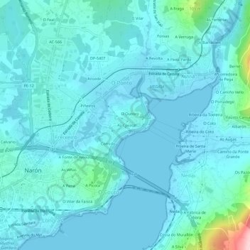
Name: As Covas topographic map, elevation, terrain.
Location: As Covas, Narón, Ferrol, La Coruña, Galicia, 15572, España (43.48830 -8.19193 43.52830 -8.15193)
Average elevation: 25 m
Minimum elevation: -3 m
Maximum elevation: 230 m
Thank you for supporting this site ❤️
Make a donation
Make a donation
Other topographic maps
Click on a map to view its topography, its elevation and its terrain.