
Φιλότι topographic map
Interactive map
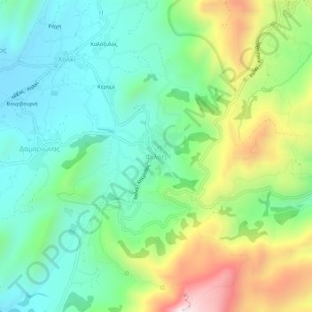
Click on the map to display elevation.
About this map
Name: Φιλότι topographic map, elevation, terrain.
Average elevation: 482 m
Minimum elevation: 251 m
Maximum elevation: 973 m
Filoti (in Greek: Φιλώτι or Φιλότι; officially: Φιλότιον) is a semi-mountainous village of central Naxos, Greece, with a population of 1,477 residents (census 2011), located at the foot of Mt. Zas (1,004 m), at an altitude of 400 meters, about 18.2 kilometres (11.3 mi) from the city of Naxos. It is located on the slopes of two hills and consists of three settlements, Rachidi, Klefaros and Lioiri. Its stand out is the Orthodox church of Panagia Filotitissa that is dedicated to the Assumption of the Virgin, a basilica built in 1718 in the place of an old Byzantine church. The economy of the village is mainly based on livestock products, secondarily in agriculture and tourism. It has a Primary School (since 1838), a Professional High School, a Multipurpose Regional Doctor, a Citizen Service Center (KEP), a Post office, a dentist and a pharmacy.
Other topographic maps
Click on a map to view its topography, its elevation and its terrain.
Naxos
Greece > Aegean > Naxos Regional Unit
Naxos, Municipality of Naxos and the Lesser Cyclades, Naxos Regional Unit, South Aegean, Aegean, 843 00, Greece
Average elevation: 33 m
Naxos
Greece > Aegean > Naxos Regional Unit
Naxos, Naxos Regional Unit, South Aegean, Aegean, Greece
Average elevation: 112 m