
Arrentières topographic map
Interactive map
Click on the map to display elevation.
About this map
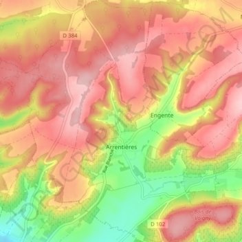
Name: Arrentières topographic map, elevation, terrain.
Average elevation: 268 m
Minimum elevation: 163 m
Maximum elevation: 335 m
La superficie de la commune est de 1 391 hectares ; son altitude varie entre 183 et 331 mètres.
Other topographic maps
Click on a map to view its topography, its elevation and its terrain.
Rue du Moulin
France > Grand Est > Aube > Argançon
Rue du Moulin, Argançon, Bar-sur-Aube, Aube, Grand Est, France métropolitaine, 10140, France
Average elevation: 215 m
Saint-Nicolas-la-Chapelle
Saint-Nicolas-la-Chapelle, Nogent-sur-Seine, Aube, Grand Est, France métropolitaine, 10400, France
Average elevation: 91 m
Voie des Brebis
France > Grand Est > Aube > Cussangy
Voie des Brebis, Cussangy, Troyes, Aube, Grand Est, France métropolitaine, 10210, France
Average elevation: 187 m
Rigny-le-Ferron
Rigny-le-Ferron, Troyes, Aube, Grand Est, France métropolitaine, 10160, France
Average elevation: 168 m
Le Village
France > Grand Est > Aube > Fouchères
Le Village, Fouchères, Troyes, Aube, Grand Est, France métropolitaine, 10260, France
Average elevation: 151 m
Mesnil-Saint-Père
Mesnil-Saint-Père, Troyes, Aube, Grand Est, France métropolitaine, 10140, France
Average elevation: 140 m
Lusigny-sur-Barse
Lusigny-sur-Barse, Troyes, Aube, Grand Est, France métropolitaine, 10270, France
Average elevation: 128 m
Landreville
France > Grand Est > Aube > Landreville > Landreville
Landreville, Troyes, Aube, Grand Est, France métropolitaine, 10110, France
Average elevation: 219 m
Nogent-sur-Seine
Nogent-sur-Seine, Aube, Grand Est, France métropolitaine, 10400, France
Average elevation: 73 m
Mailly-le-Camp
Mailly-le-Camp, Troyes, Aube, Grand Est, France métropolitaine, 10230, France
Average elevation: 153 m
Landreville
Landreville, Troyes, Aube, Grand Est, France métropolitaine, 10110, France
Average elevation: 232 m