
Yorba Linda topographic map
Interactive map
Click on the map to display elevation.
About this map
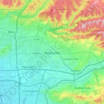
Name: Yorba Linda topographic map, elevation, terrain.
Average elevation: 175 m
Minimum elevation: 47 m
Maximum elevation: 505 m
Other topographic maps
Click on a map to view its topography, its elevation and its terrain.
Irvine
United States > California > Orange County
Irvine, Orange County, California, United States
Average elevation: 66 m
Santa Ana
United States > California > Orange County
Santa Ana, Orange County, California, United States
Average elevation: 30 m