
Thank you for supporting this site ❤️
Make a donation
Make a donation
Ohatchee topographic map
Click on the map to display elevation.
Thank you for supporting this site ❤️
Make a donation
Make a donation
About this map
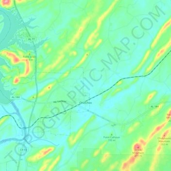
Name: Ohatchee topographic map, elevation, terrain.
Location: Ohatchee, Calhoun County, Alabama, 36271, United States (33.74462 -86.06227 33.84161 -85.98542)
Average elevation: 171 m
Minimum elevation: 139 m
Maximum elevation: 278 m
Thank you for supporting this site ❤️
Make a donation
Make a donation
Other topographic maps
Click on a map to view its topography, its elevation and its terrain.
Thank you for supporting this site ❤️
Make a donation
Make a donation
Thank you for supporting this site ❤️
Make a donation
Make a donation