
Huahine Iti topographic map
Interactive map
Click on the map to display elevation.
About this map
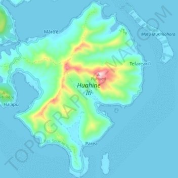
Name: Huahine Iti topographic map, elevation, terrain.
Average elevation: 47 m
Minimum elevation: -1 m
Maximum elevation: 447 m
Other topographic maps
Click on a map to view its topography, its elevation and its terrain.
Huahine Nui
France, Polynésie française (eaux territoriales) > Polynésie française > Huahine
Huahine Nui, Huahine, Îles Sous-le-Vent, Polynésie française, 98731, France, Polynésie française (eaux territoriales)
Average elevation: 54 m