
Thank you for supporting this site ❤️
Make a donation
Make a donation
Province of Celendín topographic map
Click on the map to display elevation.
Thank you for supporting this site ❤️
Make a donation
Make a donation
About this map
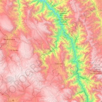
Name: Province of Celendín topographic map, elevation, terrain.
Location: Province of Celendín, Cajamarca, Peru (-7.15285 -78.45463 -6.38896 -77.95069)
Average elevation: 2,823 m
Minimum elevation: 647 m
Maximum elevation: 4,304 m
Thank you for supporting this site ❤️
Make a donation
Make a donation
Other topographic maps
Click on a map to view its topography, its elevation and its terrain.
Thank you for supporting this site ❤️
Make a donation
Make a donation
Thank you for supporting this site ❤️
Make a donation
Make a donation