
Make a donation
Buford topographic map
Click on the map to display elevation.
Make a donation
About this map
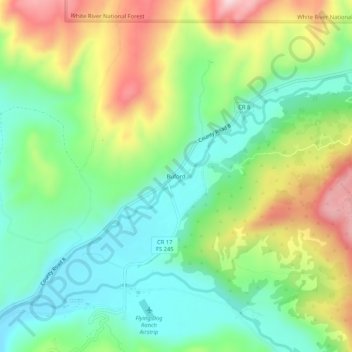
Name: Buford topographic map, elevation, terrain.
Location: Buford, Rio Blanco County, Colorado, United States (39.96720 -107.63673 40.00720 -107.59673)
Average elevation: 2,241 m
Minimum elevation: 2,113 m
Maximum elevation: 2,460 m
Make a donation
Other topographic maps
Click on a map to view its topography, its elevation and its terrain.
Meeker
United States > Colorado > Rio Blanco County
According to the United States Census Bureau, the town has a total area of 2.9 square miles (7.5 km2), all of it land. The town is situated on the White River at an elevation of 6,250 feet above sea level.
Average elevation: 2,016 m
Meeker
United States > Colorado > Rio Blanco County
According to the United States Census Bureau, the town has a total area of 2.9 square miles (7.5 km2), all of it land. The town is situated on the White River at an elevation of 6,250 feet above sea level.
Average elevation: 2,016 m
Make a donation