
Make a donation
Hot District topographic map
Click on the map to display elevation.
Make a donation
About this map
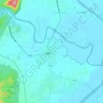
Name: Hot District topographic map, elevation, terrain.
Location: Hot District, Chiang Mai Province, 50240, Thailand (18.17414 98.59297 18.21414 98.63297)
Average elevation: 279 m
Minimum elevation: 259 m
Maximum elevation: 465 m
Make a donation
Other topographic maps
Click on a map to view its topography, its elevation and its terrain.
Thailand
Thailand comprises several distinct geographic regions, partly corresponding to the provincial groups. The north of the country is the mountainous area of the Thai highlands, with the highest point being Doi Inthanon in the Thanon Thong Chai Range at 2,565 metres (8,415 ft) elevation. The northeast, Isan,…
Average elevation: 156 m
Ko Pha Ngan
Due to its topography, the population hugs the coastline. The mountainous interior is generally inaccessible. More than half the island designated as national park and Ko Pha-ngan has more than 80 km2 (31 sq mi) of relatively unspoiled rain forest with diverse flora and fauna. It is also considered a spiritual…
Average elevation: 84 m
Bangkok
Bangkok is in the Chao Phraya River delta in Thailand's central plain. The river meanders through the city in a southerly direction, emptying into the Gulf of Thailand approximately 25 kilometres (16 mi) south of city centre. The area is flat and low-lying, with an average elevation of 1.5 metres (4 ft 11 in)…
Average elevation: 3 m
Make a donation
Bangkok
Bangkok is situated in the Chao Phraya River delta in Thailand's central plain. The river meanders through the city in a southerly direction, emptying into the Gulf of Thailand approximately 25 kilometres (16 mi) south of city centre. The area is flat and low-lying, with an average elevation of 1.5 metres (4…
Average elevation: 3 m
Phuket Province
Although some recent geographical works refer to the sections of the Tenasserim Hills in the isthmus as the "Phuket Range", these names are not found in classical geographic sources. Besides, the name Phuket is relatively recent having previously been named Jung Ceylon and Thalang. The highest elevation of the…
Average elevation: 5 m
Make a donation
Phuket Province
The island's highest point is traditionally cited as Khao Mai Thao Sip Song, with an altitude of 529 m (1,736 ft) above sea level. However, there are reports suggesting the presence of an unnamed peak in the Kamala hills, behind Kathu waterfall, which may reach an elevation of 542 meters above sea level.
Average elevation: 5 m
Make a donation
Chao Phraya River
The landscape of the river basins is a very wide, flat, well-watered plain continuously refreshed with soil and sediment brought down by the rivers. The lower central plain from the delta north to Ang Thong Province is a flat, low area with an average of two metres above sea level. Further north and into the…
Average elevation: 93 m
Chiang Mai City Municipality
Thailand > Mueang Chiang Mai District
The city is situated in a broad basin in the Thai highlands and lies at an average elevation of 300 m (1,000 ft) elevation above sea level. Chiang Mai's city centre sits west of the Ping River, a tributary to the Chao Phraya River. The city's sprawl extends outward in all directions, especially north, south,…
Average elevation: 325 m
Make a donation
Chanthaburi Province
While the southern part of the province is on the shore of the Gulf of Thailand and thus is mostly coastal alluvial plains, the interior of the province is mountainous. The Chanthaburi Mountains in the north has the highest elevation in the province, the 1,675 m high Khao Soi Dao Tai peak. The main river of…
Average elevation: 96 m
Make a donation
Khao Yai National Park
The park is the third largest in Thailand. It covers an area of 1,353,472 rai ~ 2,166 km2 (836 sq mi), including tropical seasonal forests and grasslands. Elevations mostly from 400–1,000 m (1,300–3,300 ft). There are 3,000 species of plants, 320 species of birds such as red junglefowl and coral-billed…
Average elevation: 320 m
Make a donation
Chanthaburi Province
While the southern part of the province is on the shore of the Gulf of Thailand and thus is mostly coastal alluvial plains, the interior of the province is mountainous. The Chanthaburi Mountains in the north has the highest elevation in the province, the 1,675 m high Khao Soi Dao Tai peak. The main river of…
Average elevation: 96 m
Make a donation
Bangkok
Bangkok is in the Chao Phraya River delta in Thailand's central plain. The river meanders through the city in a southerly direction, emptying into the Gulf of Thailand approximately 25 kilometres (16 mi) south of city centre. The area is flat and low-lying, with an average elevation of 1.5 metres (4 ft 11 in)…
Average elevation: 3 m
Make a donation
Make a donation
Make a donation
Chiang Mai City Municipality
Thailand > Mueang Chiang Mai District
The city is situated in a valley on a river basin in the Thai highlands and is on average at 300 m (1,000 ft) elevation. Chiang Mai's city centre sits west of the Ping River, a tributary to the Chao Phraya River, while the city's sprawl extends north-west, south-west, north-east and east of the river. To the…
Average elevation: 325 m
Make a donation
Khon Kaen City Municipality
Thailand > Mueang Khon Kaen District
Khon Kaen is on the Khorat Plateau, elevation 187 m, and is the center of the mid-northeastern provincial group of Thailand, according to the Thai government. Its coordinates are 16°26′N 102°50′E / 16.433°N 102.833°E / 16.433; 102.833. The city municipality has a population of 114,459, while…
Average elevation: 163 m
Nakhon Ratchasima City Municipality
Thailand > Mueang Nakhon Ratchasima District
Average elevation: 191 m
Make a donation
Nakhon Nayok Province
The northern part of the province is in the Sankamphaeng Range, the southern prolongation of the Dong Phaya Yen Mountains, with the highest elevation the 1,292-meter-high Yod Khao Kiew. Most of that area is covered by the Khao Yai National Park, 2,166 km2 (836 sq mi), along with three other national parks,…
Average elevation: 183 m
Make a donation
Bangkok
Bangkok is situated in the Chao Phraya River delta in Thailand's central plain. The river meanders through the city in a southerly direction, emptying into the Gulf of Thailand approximately 25 kilometres (16 mi) south of city centre. The area is flat and low-lying, with an average elevation of 1.5 metres (4…
Average elevation: 2 m
Bangkok
Bangkok is situated in the Chao Phraya River delta in Thailand's central plain. The river meanders through the city in a southerly direction, emptying into the Gulf of Thailand approximately 25 km (16 mi) south of city centre. The area is flat and low-lying, with an average elevation of 1.5 m (4 ft 11 in)…
Average elevation: 2 m
Make a donation
Chachoengsao Province
The western part of the province is the low river plain of the Bang Pa Kong River, which is used extensively for farming rice. To the east is hillier terrain, with an average elevation of more than 100 metres. In Tha Takiap District is the Khao Ang Rue Nai Wildlife Sanctuary with an area of 674,352 rai ~ 1,078…
Average elevation: 70 m
Make a donation
Make a donation
Nakhon Ratchasima City Municipality
Thailand > Mueang Nakhon Ratchasima District
Average elevation: 191 m
Chiang Mai City Municipality
Thailand > Mueang Chiang Mai District
The city is situated in a valley on a river basin in the Thai highlands and is on average at 300 m (1,000 ft) elevation. Chiang Mai's city centre sits west of the Ping River, a tributary to the Chao Phraya River, while the city's sprawl extends north-west, south-west, north-east and east of the river. To the…
Average elevation: 325 m
Make a donation
Make a donation
Phuket Province
The island's highest point is traditionally cited as Khao Mai Thao Sip Song, with an altitude of 529 m (1,736 ft) above sea level. However, there are reports suggesting the presence of an unnamed peak in the Kamala Hills, behind Kathu Waterfall, which may reach an elevation of 542 meters above sea level.
Average elevation: 5 m
Make a donation
Make a donation
Make a donation
Make a donation
Kanchanaburi Province
The province is in the west of Thailand, 129 km from Bangkok, and covers a total area of approximately 19,482 km2 (7,522 sq mi). It is the country's third largest province, after Nakhon Ratchasima and Chiang Mai. Topographically, it is covered with timber and evergreen forests. The total forest area is 11,990…
Average elevation: 297 m
Make a donation
Make a donation
Mae Haad Cove (Nudist Beach)
Thailand > Ko Pha-ngan District > Baan Wang Ta Kien > Haad Mae Haad
Average elevation: 42 m
Make a donation