
Thank you for supporting this site ❤️
Make a donation
Make a donation
Ouled Chebacheb topographic map
Click on the map to display elevation.
Thank you for supporting this site ❤️
Make a donation
Make a donation
About this map
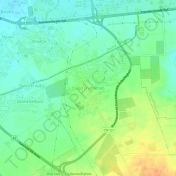
Name: Ouled Chebacheb topographic map, elevation, terrain.
Average elevation: 36 m
Minimum elevation: 21 m
Maximum elevation: 60 m
Thank you for supporting this site ❤️
Make a donation
Make a donation
Other topographic maps
Click on a map to view its topography, its elevation and its terrain.
Khemis El Khechna
Algeria > Boumerdès > Khemis El Khechna District > Khemis El Khechna
Average elevation: 237 m