
Thank you for supporting this site ❤️
Make a donation
Make a donation
Sobral de Baixo topographic map
Click on the map to display elevation.
Thank you for supporting this site ❤️
Make a donation
Make a donation
About this map
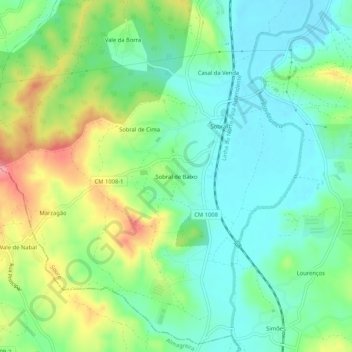
Name: Sobral de Baixo topographic map, elevation, terrain.
Location: Sobral de Baixo, Soure, Coimbra, 3130-548, Portugal (40.00918 -8.66941 40.04918 -8.62941)
Average elevation: 50 m
Minimum elevation: 12 m
Maximum elevation: 125 m
Thank you for supporting this site ❤️
Make a donation
Make a donation
Other topographic maps
Click on a map to view its topography, its elevation and its terrain.