
Priézac topographic map
Interactive map
Click on the map to display elevation.
About this map
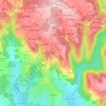
Name: Priézac topographic map, elevation, terrain.
Average elevation: 275 m
Minimum elevation: 136 m
Maximum elevation: 391 m
Other topographic maps
Click on a map to view its topography, its elevation and its terrain.
La Barrière
France > Nouvelle-Aquitaine > Corrèze > Saint-Solve
La Barrière, Saint-Solve, Brive-la-Gaillarde, Corrèze, Nouvelle-Aquitaine, France métropolitaine, 19130, France
Average elevation: 190 m
Meilhard
France > Nouvelle-Aquitaine > Corrèze > Saint-Solve > Priézac
Meilhard, Priézac, Saint-Solve, Brive-la-Gaillarde, Corrèze, Nouvelle-Aquitaine, France métropolitaine, 19130, France
Average elevation: 315 m
Bellevue
France > Nouvelle-Aquitaine > Corrèze > Saint-Solve
Bellevue, Saint-Solve, Brive-la-Gaillarde, Corrèze, Nouvelle-Aquitaine, France métropolitaine, 19130, France
Average elevation: 206 m
Le Verdier
France > Nouvelle-Aquitaine > Corrèze > Saint-Solve
Le Verdier, Saint-Solve, Brive-la-Gaillarde, Corrèze, Nouvelle-Aquitaine, France métropolitaine, 19130, France
Average elevation: 256 m