
永平乡 topographic map
Interactive map
Click on the map to display elevation.
About this map
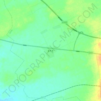
Name: 永平乡 topographic map, elevation, terrain.
Location: 永平乡, 松原市, 吉林省, 中国 (45.11865 125.02865 45.19865 125.10865)
Average elevation: 159 m
Minimum elevation: 148 m
Maximum elevation: 178 m
Other topographic maps
Click on a map to view its topography, its elevation and its terrain.