
Make a donation
Magglingen topographic map
Click on the map to display elevation.
Make a donation
About this map
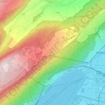
Name: Magglingen topographic map, elevation, terrain.
Average elevation: 705 m
Minimum elevation: 424 m
Maximum elevation: 1,086 m
Make a donation
Other topographic maps
Click on a map to view its topography, its elevation and its terrain.
Biel/Bienne
Switzerland > Bern > Biel/Bienne administrative district
One funicular railways leads to the national sports center of Magglingen/Macolin on the 500 metres (1,600 ft) higher Jura mountain in the west, and the other, the Bienne-Evilard Funicular, to the city hospital and to neighbouring municipality Evilard to northwest, both above the town on the eastern range of…
Average elevation: 655 m
Evilard
Switzerland > Bern > Biel/Bienne administrative district
The municipality reaches to the height of the anticline of Montagen de Macolin. It includes the town of Evilard, which is surrounded by Malvaux (German: Malewagwald, up to 765 m (2,510 ft) altitude). To the southwest, the municipality reaches in a narrow strip over the Magglingen to the peak of the…
Average elevation: 583 m
Make a donation