
Thank you for supporting this site ❤️
Make a donation
Make a donation
es Sendet topographic map
Click on the map to display elevation.
Thank you for supporting this site ❤️
Make a donation
Make a donation
About this map
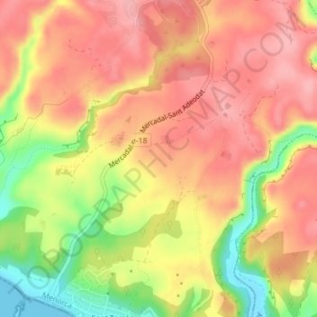
Name: es Sendet topographic map, elevation, terrain.
Average elevation: 76 m
Minimum elevation: 0 m
Maximum elevation: 120 m
Thank you for supporting this site ❤️
Make a donation
Make a donation
Other topographic maps
Click on a map to view its topography, its elevation and its terrain.
Platja de Sant Tomàs
Espagne > Îles Baléares > Minorque > es Migjorn Gran > Sant Tomàs
Average elevation: 22 m