
Thank you for supporting this site ❤️
Make a donation
Make a donation
Lone Cone topographic map
Click on the map to display elevation.
Thank you for supporting this site ❤️
Make a donation
Make a donation
About this map
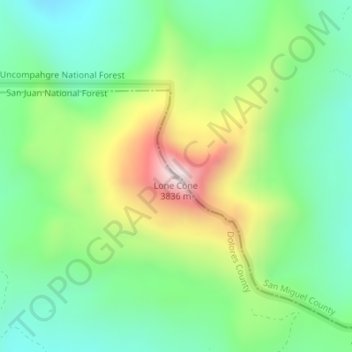
Name: Lone Cone topographic map, elevation, terrain.
Location: Lone Cone, Dolores County, Colorado, United States (37.88800 -108.25596 37.88810 -108.25586)
Average elevation: 3,393 m
Minimum elevation: 3,168 m
Maximum elevation: 3,821 m
Thank you for supporting this site ❤️
Make a donation
Make a donation
Other topographic maps
Click on a map to view its topography, its elevation and its terrain.
Rico
United States > Colorado > Dolores County
Rico experiences an alpine subarctic climate (Köppen climate classification Dfc) with long, cold, very snowy winters and short, cool summers due to the high altitude and high precipitation year-round due to orographic lift.
Average elevation: 2,861 m