
Thank you for supporting this site ❤️
Make a donation
Make a donation
Las Vegas topographic map
Click on the map to display elevation.
Thank you for supporting this site ❤️
Make a donation
Make a donation
Las Vegas
The city's elevation is approximately 2,030 ft (620 m) above sea level, though the surrounding peaks reach elevations of over 10,000 feet (3,000 m) and act as barriers to the strong flow of moisture from the surrounding area. According to the United States Census Bureau, the city has an area of 135.86 sq mi (351.9 km2), of which 135.81 sq mi (351.7 km2) is land and 0.05 sq mi (0.13 km2) (0.03%) is water.
Thank you for supporting this site ❤️
Make a donation
Make a donation
About this map
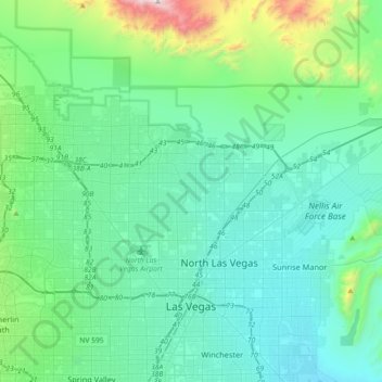
Name: Las Vegas topographic map, elevation, terrain.
Location: Las Vegas, Clark County, Nevada, United States (36.12955 -115.42428 36.38084 -115.06207)
Average elevation: 756 m
Minimum elevation: 505 m
Maximum elevation: 2,100 m
Thank you for supporting this site ❤️
Make a donation
Make a donation