
Make a donation
Subotica topographic map
Click on the map to display elevation.
Make a donation
Subotica
It is located in Central Europe at the Pannonian Basin at 46.07° North, 19.68° East, at the altitude of 109m, about 10 kilometres (6 miles) from the border with Hungary, and is the northernmost city in Serbia. Lake Palić is in the immediate vicinity of the city. Sand dunes area Subotička Peščara is located north of the city, along the Hungarian border.
Make a donation
About this map
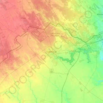
Name: Subotica topographic map, elevation, terrain.
Average elevation: 115 m
Minimum elevation: 87 m
Maximum elevation: 140 m
Make a donation
Other topographic maps
Click on a map to view its topography, its elevation and its terrain.
Mali Idjos
Serbia > Vojvodina > North Backa Administrative District > Mali Idjos Municipality
Average elevation: 103 m
Bačka Topola
Serbia > Vojvodina > North Backa Administrative District > Backa Topola Municipality
Average elevation: 106 m
Make a donation