
Kalay Township topographic map
Interactive map
Click on the map to display elevation.
About this map
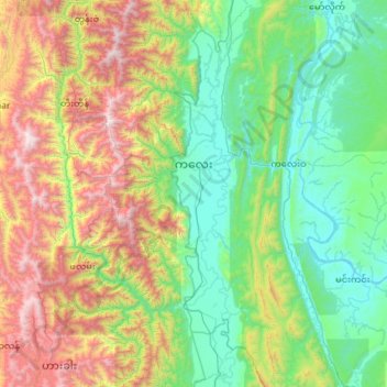
Name: Kalay Township topographic map, elevation, terrain.
Location: Kalay Township, Kale District, Sagaing Region, Myanmar (22.58301 93.94319 23.65608 94.27883)
Average elevation: 741 m
Minimum elevation: 80 m
Maximum elevation: 2,666 m
Other topographic maps
Click on a map to view its topography, its elevation and its terrain.
Kani Township
Kani Township, Yinmabin District, Sagaing Region, Myanmar
Average elevation: 201 m