
Make a donation
Gdańsk topographic map
Click on the map to display elevation.
Make a donation
About this map
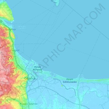
Name: Gdańsk topographic map, elevation, terrain.
Location: Gdańsk, Poland (54.27492 18.42950 54.58273 19.07030)
Average elevation: 13 m
Minimum elevation: -5 m
Maximum elevation: 168 m
Make a donation
Other topographic maps
Click on a map to view its topography, its elevation and its terrain.
Make a donation
Make a donation
Warsaw
Poland > Masovian Voivodeship > Warsaw
Warsaw lies in east-central Poland about 300 kilometres (190 mi) from the Carpathian Mountains and about 260 kilometres (160 mi) from the Baltic Sea, 523 kilometres (325 mi) east of Berlin, Germany. The city straddles the Vistula River. It is located in the heartland of the Masovian Plain, and its average…
Average elevation: 95 m
Make a donation
Make a donation
Make a donation
Warsaw
Poland > Masovian Voivodeship > Warsaw
Warsaw lies in east-central Poland about 300 kilometres (190 mi) from the Carpathian Mountains and about 260 kilometres (160 mi) from the Baltic Sea, 523 kilometres (325 mi) east of Berlin, Germany. The city straddles the Vistula River. It is located in the heartland of the Masovian Plain, and its average…
Average elevation: 95 m
Make a donation
Góry Kaczawskie
Poland > Lower Silesian Voivodeship > Złotoryja County > Wojcieszów
Average elevation: 526 m
Make a donation
Make a donation
Make a donation
Make a donation
Haliga
Poland > Subcarpathian Voivodeship > Przemyśl County > Przedmieście Dubieckie
Average elevation: 271 m
Make a donation
Mokłuczka
Poland > Subcarpathian Voivodeship > Rzeszów County > Błażowa Dolna
Average elevation: 320 m
Szubianka
Poland > Lower Silesian Voivodeship > Kamienna Góra County > Kamienna Góra
Average elevation: 468 m
Make a donation
Make a donation
Góry Sowie
Poland > Lower Silesian Voivodeship > Wałbrzych County > Rzeczka
Seen from the Silesian Lowlands in the northeast, the Owl Mountains form a comparatively steep edge of the Central Sudetes, though the range is very diversified in terms of height. The highest peaks are Wielka Sowa ("Great Owl", at 1,014 m (3,327 ft) in altitude) and Kalenica (964 m (3,163 ft)) with their…
Average elevation: 831 m
Kopciowa
Poland > Lower Silesian Voivodeship > Ząbkowice Śląskie County > Chwalisław
Average elevation: 591 m
Make a donation
Górny Koniec
Poland > Subcarpathian Voivodeship > Dębica County > Stara Jastrząbka
Average elevation: 240 m
Make a donation
Make a donation
Warsaw
Poland > Masovian Voivodeship > Warsaw
Warsaw lies in east-central Poland about 300 km (190 mi) from the Carpathian Mountains and about 260 km (160 mi) from the Baltic Sea, 523 km (325 mi) east of Berlin, Germany. The city straddles the Vistula River. It is located in the heartland of the Masovian Plain, and its average elevation is 100 m (330 ft)…
Average elevation: 95 m
Make a donation
Make a donation
Make a donation
Make a donation
Make a donation
Góry Świętokrzyskie
Poland > Holy Cross Voivodeship > Kielce County > Kakonin
Average elevation: 440 m
Make a donation
Rysy
Poland > Lesser Poland Voivodeship > Tatra County > Brzegi
It is possible to reach the peak from the Slovak side, starting at Štrbské pleso and passing Chata pod Rysmi, a mountain chalet at an altitude of 2,250 m (7,380 ft). Between November 1 and June 1, the trail and chalet on the Slovak side are closed.
Average elevation: 2,005 m
Make a donation
Śnieżka / Sněžka
Poland > Lower Silesian Voivodeship > Karkonosze County > Karpacz
Due to high altitude the climate is maritime polar (Köppen: ET) not far from a continental subpolar climate (Dfc). The difference should be at least 6 °C lower on annual average compared to the weather station in the plains.
Average elevation: 1,263 m
Make a donation
Zwardoń
Poland > Silesian Voivodeship > Żywiec County
Zwardoń, located at the elevation of 690 meters above sea level, is placed between three mountain passes - Przysłop, Zwardońska and Graniczne. Until 1975, the village was administratively tied with Kraków and Lesser Poland. In 1975 - 1999, it belonged to Bielsko-Biala Voivodeship, and after the territorial…
Average elevation: 710 m
Make a donation