
Thank you for supporting this site ❤️
Make a donation
Make a donation
Kozielec topographic map
Click on the map to display elevation.
Thank you for supporting this site ❤️
Make a donation
Make a donation
About this map
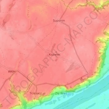
Name: Kozielec topographic map, elevation, terrain.
Average elevation: 80 m
Minimum elevation: 20 m
Maximum elevation: 98 m
Thank you for supporting this site ❤️
Make a donation
Make a donation
Other topographic maps
Click on a map to view its topography, its elevation and its terrain.
Zalew Koronowski
Poland > Kuyavian-Pomeranian Voivodeship > Bydgoszcz County > Koronowo
Average elevation: 101 m