
Thank you for supporting this site ❤️
Make a donation
Make a donation
Sint-Amandsberg topographic map
Click on the map to display elevation.
Thank you for supporting this site ❤️
Make a donation
Make a donation
About this map
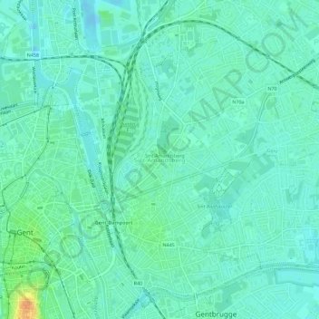
Name: Sint-Amandsberg topographic map, elevation, terrain.
Location: Sint-Amandsberg, Gent, Ostflandern, Flandern, 9040, Belgien (51.04640 3.74327 51.07740 3.79977)
Average elevation: 8 m
Minimum elevation: -8 m
Maximum elevation: 33 m
Thank you for supporting this site ❤️
Make a donation
Make a donation
Other topographic maps
Click on a map to view its topography, its elevation and its terrain.
Gent
Belgien > Ostflandern > Gent > Gent
Das Stadtzentrum unterteilt sich in mehrere auf frühere Ansiedlungen zurückgehende Kerne, der Unterschied zwischen dem historischen mittelalterlichen Zentrum in der sogenannten „Wanne“ (De Kuip) und dem deutlich höherliegenden Gebiet der ehemaligen Sankt-Peters-Abtei auf dem Blandinberg macht sich…
Average elevation: 12 m